

OsmAnd+ — Maps & GPS Offline
In-app purchases

4.6star
39.8K reviews
100K+
Downloads

PEGI 3
info

About this app
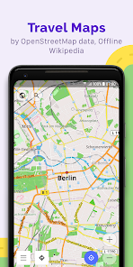
OsmAnd+ is an offline world map application based on OpenStreetMap (OSM), which allows you to navigate taking into account the preferred roads and vehicle dimensions. Plan routes based on inclines and record GPX tracks without an internet connection.
OsmAnd+ is an open source app. We do not collect user data and you decide what data the app will have access to.
Main features:
OsmAnd+ privileges (Maps+)
• Android Auto support;
• Unlimited map downloads;
• Topo data (Contour lines and Terrain);
• Nautical depths;
• Offline Wikipedia;
• Offline Wikivoyage - Travel guides;
Map view
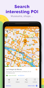
• Choice of places to be displayed on the map: attractions, food, health and more;
• Search for places by address, name, coordinates, or category;
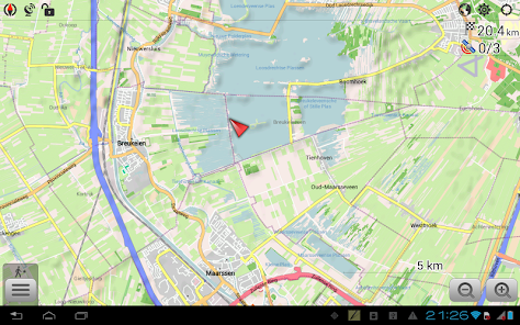
• Map styles for the convenience of different activities: touring view, nautical map, winter and ski, topographic, desert, off-road, and others;
• Shading relief and plug-in contour lines;
• Ability to overlay different sources of maps on top of each other;
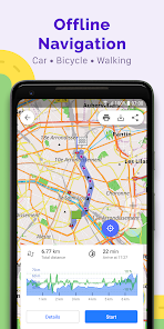
GPS Navigation
• Plotting a route to a place without an Internet connection;
• Customizable navigation profiles for different vehicles: cars, motorcycles, bicycles, 4x4, pedestrians, boats, public transport, and more;
• Change the constructed route, taking into account the exclusion of certain roads or road surfaces;
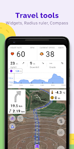
• Customizable information widgets about the route: distance, speed, remaining travel time, distance to turn, and more;
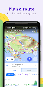
Route Planning and Recording
• Plotting a route point by point using one or multiple navigation profiles;
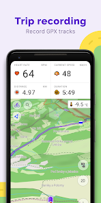
• Route recording using GPX tracks;
• Manage GPX tracks: displaying your own or imported GPX tracks on the map, navigating through them;
• Visual data about the route - descents/ascents, distances;
• Ability to share GPX track in OpenStreetMap;
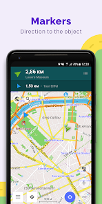
Creation of points with different functionality
• Favourites;
• Markers;
• Audio/video notes;
OpenStreetMap
• Making edits to OSM;
• Updating maps with a frequency of up to one hour;
Additional features
• Compass and radius ruler;
• Mapillary interface;
• Nautical depths;
• Offline Wikipedia;
• Offline Wikivoyage - Travel guides;
• Night theme;
• Large community of users around the world, documentation, and support;
Paid features:
OsmAnd Pro (subscription)
• OsmAnd Cloud (backup and restore);
• Cross-platform;
• Hourly map updates;
• Weather plugin;
• Elevation widget;
• Customise route line;
• External sensors support (ANT+, Bluetooth);
• Online Elevation profile.
OsmAnd+ is an open source app. We do not collect user data and you decide what data the app will have access to.
Main features:
OsmAnd+ privileges (Maps+)
• Android Auto support;
• Unlimited map downloads;
• Topo data (Contour lines and Terrain);
• Nautical depths;
• Offline Wikipedia;
• Offline Wikivoyage - Travel guides;
Map view
• Choice of places to be displayed on the map: attractions, food, health and more;
• Search for places by address, name, coordinates, or category;
• Map styles for the convenience of different activities: touring view, nautical map, winter and ski, topographic, desert, off-road, and others;
• Shading relief and plug-in contour lines;
• Ability to overlay different sources of maps on top of each other;
GPS Navigation
• Plotting a route to a place without an Internet connection;
• Customizable navigation profiles for different vehicles: cars, motorcycles, bicycles, 4x4, pedestrians, boats, public transport, and more;
• Change the constructed route, taking into account the exclusion of certain roads or road surfaces;
• Customizable information widgets about the route: distance, speed, remaining travel time, distance to turn, and more;
Route Planning and Recording
• Plotting a route point by point using one or multiple navigation profiles;
• Route recording using GPX tracks;
• Manage GPX tracks: displaying your own or imported GPX tracks on the map, navigating through them;
• Visual data about the route - descents/ascents, distances;
• Ability to share GPX track in OpenStreetMap;
Creation of points with different functionality
• Favourites;
• Markers;
• Audio/video notes;
OpenStreetMap
• Making edits to OSM;
• Updating maps with a frequency of up to one hour;
Additional features
• Compass and radius ruler;
• Mapillary interface;
• Nautical depths;
• Offline Wikipedia;
• Offline Wikivoyage - Travel guides;
• Night theme;
• Large community of users around the world, documentation, and support;
Paid features:
OsmAnd Pro (subscription)
• OsmAnd Cloud (backup and restore);
• Cross-platform;
• Hourly map updates;
• Weather plugin;
• Elevation widget;
• Customise route line;
• External sensors support (ANT+, Bluetooth);
• Online Elevation profile.
Updated on
Safety starts with understanding how developers collect and share your data. Data privacy and security practices may vary based on your use, region, and age. The developer provided this information and may update it over time.

No data shared with third parties
Learn more about how developers declare sharing

This app may collect these data types
Personal info, Photos and videos and 5 others

Data is encrypted in transit

You can request that data be deleted
Ratings and reviews
4.6
35.2K reviews

Daniel Z
- Flag inappropriate
August 13, 2024
I went on a trip recently, from Graz to Munich, and it didn't go well. Route calculation for that specific route takes 15 minutes and not just at the beginning. Also, every time, the app loses the gps signal in a tunnel. Also, when losing the gps signal in a tunnel, your location starts teleporting a few hundred kilometers in a random direction instead of estimating speed and staying in the tunnel. Also, search functions like an old-school Navi device, which is cumbersome.
3 people found this review helpful
OsmAnd
August 14, 2024
Hello, Daniel! Thank you for the feedback.
Please make sure that all maps are up-to-date, this is required for new routing algorithm. We will check app behavior in the tunnels. If you have any other questions, please contact us at support@osmand.net

scnnr online
- Flag inappropriate
September 11, 2024
This app can be an ordinary person's nightmare to use. Requires a good quality primer on how to get best use of map. In areas like central London a surprising number of local details are a few *years* out of date, and the screen gets saturated with icons for parking places, etc, to the point itt obscures the streets(!) and completely unnecessary for pedestrians or those mainly using public transport. Please urgently consider redesigning this difficult app. Astonishing.
1 person found this review helpful
OsmAnd
September 12, 2024
Hello! Thank you for the feedback.

Chris Heath
- Flag inappropriate
August 1, 2024
It become a nightmare. I used to love this app for planning a route, but not having used it for a while I now find it is awful. It is very very slow, eats battery power like there is no tomorrow, crashes while calculating a route. In fact there is nothing to recommend it. It's user interface is missing basic functions like deleting a saved route. I'm afraid I am going to cancel my subscription and go to a more reliable app even if I have to pay more.
6 people found this review helpful
What's new
• New terrain colorization option "Altitude"
• Custom color palettes for terrain, tracks, and routes
• 3D variant for location position icons
• Quick Actions can now be assigned to external keyboards
• Weather: UI refresh, added wind animation
• 3D Track Improvements: new visualization and colorization options
• Expanded selection of tourist routes on the map
• Added app theme option to follow map mode
• Fixed track stats, sorting & search
App support
About the developer
OsmAND B.V.
victor.shcherb@osmand.net
Logger 41
1186 RM Amstelveen
Netherlands
+31 6 19804549


