

OsmAnd — Maps & GPS Offline
In-app purchases

4.6star
197K reviews
10M+
Downloads

PEGI 3
info
About this app
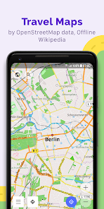
OsmAnd is an offline world map application based on OpenStreetMap (OSM), which allows you to navigate taking into account the preferred roads and vehicle dimensions. Plan routes based on inclines and record GPX tracks without an internet connection.
OsmAnd is an open source app. We do not collect user data and you decide what data the app will have access to.
Main features:
Map view
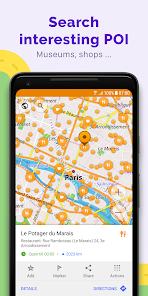
• Choice of places to be displayed on the map: attractions, food, health and more;
• Search for places by address, name, coordinates, or category;
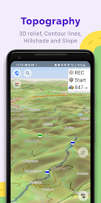
• Map styles for the convenience of different activities: touring view, nautical map, winter and ski, topographic, desert, off-road, and others;
• Shading relief and plug-in contour lines;
• Ability to overlay different sources of maps on top of each other;
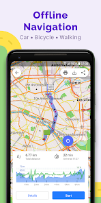
GPS Navigation
• Plotting a route to a place without an Internet connection;
• Customizable navigation profiles for different vehicles: cars, motorcycles, bicycles, 4x4, pedestrians, boats, public transport, and more;
• Change the constructed route, taking into account the exclusion of certain roads or road surfaces;
• Customizable information widgets about the route: distance, speed, remaining travel time, distance to turn, and more;
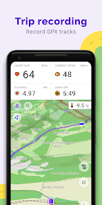
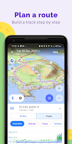
Route Planning and Recording
• Plotting a route point by point using one or multiple navigation profiles;
• Route recording using GPX tracks;
• Manage GPX tracks: displaying your own or imported GPX tracks on the map, navigating through them;
• Visual data about the route - descents/ascents, distances;
• Ability to share GPX track in OpenStreetMap;
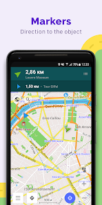
Creation of points with different functionality
• Favourites;
• Markers;
• Audio/video notes;
OpenStreetMap
• Making edits to OSM;
• Updating maps with a frequency of up to one hour;
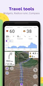
Additional features
• Compass and radius ruler;
• Mapillary interface;
• Night theme;
• Wikipedia;
• Large community of users around the world, documentation, and support;
Paid features:
Maps+ (in-app or subscription)
• Android Auto support;
• Unlimited map downloads;
• Topo data (Contour lines and Terrain);
• Nautical depths;
• Offline Wikipedia;
• Offline Wikivoyage - Travel guides.
OsmAnd Pro (subscription)
• OsmAnd Cloud (backup and restore);
• Cross-platform;
• Hourly map updates;
• Weather plugin;
• Elevation widget;
• Customise route line;
• External sensors support (ANT+, Bluetooth);
• Online Elevation profile.
OsmAnd is an open source app. We do not collect user data and you decide what data the app will have access to.
Main features:
Map view
• Choice of places to be displayed on the map: attractions, food, health and more;
• Search for places by address, name, coordinates, or category;
• Map styles for the convenience of different activities: touring view, nautical map, winter and ski, topographic, desert, off-road, and others;
• Shading relief and plug-in contour lines;
• Ability to overlay different sources of maps on top of each other;
GPS Navigation
• Plotting a route to a place without an Internet connection;
• Customizable navigation profiles for different vehicles: cars, motorcycles, bicycles, 4x4, pedestrians, boats, public transport, and more;
• Change the constructed route, taking into account the exclusion of certain roads or road surfaces;
• Customizable information widgets about the route: distance, speed, remaining travel time, distance to turn, and more;
Route Planning and Recording
• Plotting a route point by point using one or multiple navigation profiles;
• Route recording using GPX tracks;
• Manage GPX tracks: displaying your own or imported GPX tracks on the map, navigating through them;
• Visual data about the route - descents/ascents, distances;
• Ability to share GPX track in OpenStreetMap;
Creation of points with different functionality
• Favourites;
• Markers;
• Audio/video notes;
OpenStreetMap
• Making edits to OSM;
• Updating maps with a frequency of up to one hour;
Additional features
• Compass and radius ruler;
• Mapillary interface;
• Night theme;
• Wikipedia;
• Large community of users around the world, documentation, and support;
Paid features:
Maps+ (in-app or subscription)
• Android Auto support;
• Unlimited map downloads;
• Topo data (Contour lines and Terrain);
• Nautical depths;
• Offline Wikipedia;
• Offline Wikivoyage - Travel guides.
OsmAnd Pro (subscription)
• OsmAnd Cloud (backup and restore);
• Cross-platform;
• Hourly map updates;
• Weather plugin;
• Elevation widget;
• Customise route line;
• External sensors support (ANT+, Bluetooth);
• Online Elevation profile.
Updated on
Safety starts with understanding how developers collect and share your data. Data privacy and security practices may vary based on your use, region and age The developer provided this information and may update it over time.

No data shared with third parties
Learn more about how developers declare sharing

This app may collect these data types
Personal info, Photos and videos and 5 others

Data is encrypted in transit

You can request that data be deleted
Ratings and reviews
4.5
184K reviews

Maks J
- Flag inappropriate
14 August 2024
Haven't been able to use the app properly as you can't find a specific address!! I've tried so many different options and nothing works. I thought that maybe I'm just being stupid, but it turns out it's a very common issue with this app. I even typed in a city like London and low and behold, it didn't find it 🤦🏽😂 All the other features seems to be pretty decent, such a bike route, all the map gadgets such as weather etc, it's just a shame that you can't type in the address 🙈
2 people found this review helpful
OsmAnd
15 August 2024
Hello, Maks! Thank you for the feedback.
Offline maps is required for searching. You can try to use step-by-step address search in Menu – Search – Address. If it doesn't help, please contact us at support@osmand.net

Carlos R
- Flag inappropriate
12 August 2024
This is probably one of the best mapping apps available. It relies on OpenStreetMap (open-source, community project), which already makes it great, and it provides good navigation and plenty of information. Only thing is that it's important not to rely on the app unless you know the map is good because some parts of the world are still partially unmapped and business info is limited.
19 people found this review helpful

Peter Knights
- Flag inappropriate
- Show review history
12 September 2024
Bought the paid version for the motorhome features but not overly impressed. Routes will often not be found or the route is too long to be plotted after taking an age to load it. Reverted to using Google maps for the long distance sections (instantly loaded) then this for the shorter non motorway parts where a specific route for the van may be needed. Tested mostly in the South of France early 2024. Often gave wrong roundabout exit instructions (correct if going the wrong way round the island).
OsmAnd
12 September 2024
Hello, Peter! Thank you for the feedback.
Could you please send to support@osmand.net coordinates of the start and destination points of the route so we could investigate it?
What's new
• New terrain colorization option "Altitude"
• Custom color palettes for terrain, tracks, and routes
• 3D variant for location position icons
• Quick Actions can now be assigned to external keyboards
• Weather: UI refresh, added wind animation
• 3D Track Improvements: new visualization and colorization options
• Expanded selection of tourist routes on the map
• Added app theme option to follow map mode
• Fixed track stats, sorting & search
App support
About the developer
OsmAND B.V.
victor.shcherb@osmand.net
Logger 41
1186 RM Amstelveen
Netherlands
+31 6 19804549


